A Review of Applications of Deep Learning-Driven Multi-Source Remote Sensing Spatiotemporal Fusion in Wetland Monitoring
Keywords:
Deep Learning, Multi-source Remote Sensing, Spatiotemporal Fusion, Wetland MonitoringAbstract
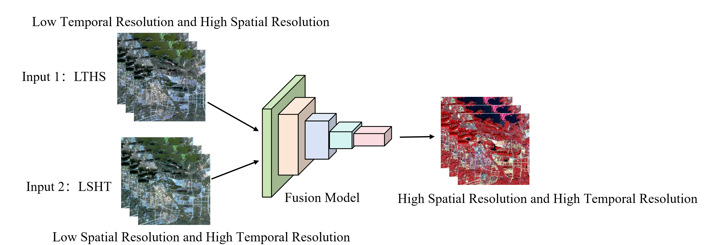
Wetlands are vital ecosystems on Earth, and the dynamic monitoring of their changes is crucial for ecological conservation, biodiversity maintenance, and water resource management. Multi-source remote sensing spatiotemporal fusion technology can integrate the advantages of datasets with different spatiotemporal resolutions to generate image sequences with high spatiotemporal resolution, providing core data support for dynamic wetland monitoring. By virtue of its powerful feature extraction and nonlinear fitting capabilities, deep learning has greatly improved the accuracy and adaptability of spatiotemporal fusion, driving wetland monitoring toward refinement and dynamization. This paper systematically sorts out the research background and significance of deep learning-driven multi-source remote sensing spatiotemporal fusion technology, categorically elaborates on mainstream fusion models, summarizes their application achievements in four core scenarios (wetland boundary extraction, type classification, ecological parameter inversion, and dynamic change monitoring), analyzes the key problems faced by current technologies, and prospects future research directions, thereby providing a reference for the in-depth application of this technology in wetland monitoring.
References
Mammen R. (2025). Urban commons in the face of climate change: The challenge of private wetland conservation. Jindal Global Law Review, 1-32.
Zedler, J. B., & Kercher, S. (2005). Wetland resources: Status, trends, ecosystem services, and restorability. Annual Review of Environment and Resources, 30, 39-74.
Davidson, N. C. (2014). The role of wetlands in the global carbon cycle. Current Opinion in Environmental Sustainability, 5, 71-77.
Ballut-Dajud A, Sandoval Herazo L , Fernández-Lambert G, et al.(2022). Factors affecting wetland loss: A review. Land, 11(3): 434.
Davidson, N. C. (2018). Global wetland area change (1970–2015) from Landsat images, remote sensing and GIS analysis. Regional Environmental Change, 18(6), 1621-1633.
Gao, F., Masek, J., & Schwaller, M. (2006). On the blending of the Landsat and MODIS surface reflectance: Predicting daily Landsat surface reflectance. IEEE Transactions on Geoscience and Remote Sensing, 44(8), 2207-2218.
Wulder, M. A., Coops, N. C., & Roy, D. P. (2019). Landsat-8 and Sentinel-2: Current status and future prospects for terrestrial monitoring. Remote Sensing of Environment, 221, 375-384.
Miura Y, Shamsudduha M, Suppasri A, et al. (2025). A global multi-sensor dataset of surface water indices from Landsat-8 and Sentinel-2 satellite measurements. Scientific data,12(1): 1253-1266.
Verbesselt, J., Hyndman, R., Newnham, G., & Culvenor, D. (2010). Detecting trend and seasonal changes in satellite image time series. Remote Sensing of Environment, 114(1), 106-115.
Justice, C. O., Vermote, E., Townshend, J. R., et al. (1998). The moderate resolution imaging spectroradiometer (MODIS): Land remote sensing for global change research. IEEE Transactions on Geoscience and Remote Sensing, 36(4), 1228-1249.
Baronian I, Borna R, Jafarpour K, et al. (2024). Unveiling the thermal impact of land cover transformations in Khuzestan province through MODIS satellite remote sensing products. Paddy and Water Environment, 22(4): 503-520.
Zhu, X., Chen, J., Gao, F., et al. (2016). An enhanced spatial and temporal adaptive reflectance fusion model for complex heterogeneous regions.Remote Sensing of Environment, 186, 45-61.
Wang, Q., Atkinson, P. M., & Yang, W. (2018). Spatiotemporal fusion of remote sensing images: A review. Information Fusion, 42, 75-89.
He, K., Zhang, X., Ren, S., & Sun, J. (2016). Deep residual learning for image recognition. In Proceedings of the IEEE conference on computer vision and pattern recognition (pp. 770-778).
Wang, Yi D, et al. (2025) "A temporal attention-based multi-scale generative adversarial network to fill gaps in time series of MODIS data for land surface phenology extraction."Remote Sensing of Environment, 318: 114546.
Shinkarenko, S. S., & Bartalev, S. A. (2024). Application of remote sensing data in large-scale monitoring of wetlands. Cosmic Research, 62(1), S100-S114.
Zhu, Zhi H, et al.(2025) Research on Crop Classification Using U-Net Integrated with Multimodal Remote Sensing Temporal Features.Sensors,25(16) : 5005.
Zhang, Zhi cheng, et al. (2025). A land-cover-assisted super-resolution model for retrospective reconstruction of MODIS-like NDVI data across the continental United States by blending Landcover300m and GIMMS NDVI3g data.Ecological Indicators,17(1):113176.
Cui Y, Jia K, Wei H, et al. (2025). Glacier Extraction from Cloudy Satellite Images Using a Multi-Task Generative Adversarial Network Leveraging Transformer-Based Backbones. Remote Sensing, 17(21): 3570.
Wang, Ruikun, et al. (2024). Transformers for remote sensing: A systematic review and analysis. Sensors,11: 3495-3518.
LeCun, Y., Bengio, Y., & Hinton, G. (2015). Deep learning. Nature, 521(7553), 436-444.
Pelletier, Charlotte, Geoffrey I. Webb, and François Petitjean. (2019). Temporal convolutional neural network for the classification of satellite image time series.Remote Sensing,11(5): 523-548.
Zhang, Y., Liu, Q., & Wang, Y. (2018). Edge-preserving spatiotemporal fusion for remote sensing images using a convolutional neural network. IEEE Geoscience and Remote Sensing Letters, 15(11), 1734-1738.
Chen, L. C., Papandreou, G., Kokkinos, I., et al. (2017). DeepLab: Semantic image segmentation with deep convolutional nets, atrous convolution, and fully connected CRFs. IEEE Transactions on Pattern Analysis and Machine Intelligence, 40(4), 834-848.
Li, Nan, et al. (2024). CRAUnet++: A New Convolutional Neural Network for Land Surface Water Extraction from Sentinel-2 Imagery by Combining RWI with Improved Unet++.Remote Sensing,16 (18): 3391-3411.
Wu, Caifeng, et al. (2024). Multi-Stage Frequency Attention Network for Progressive Optical Remote Sensing Cloud Removal.Remote Sensing,16 (15): 2867-2892.
Lian, Zilong, et al. (2025). Recent Advances in Deep Learning-Based Spatiotemporal Fusion Methods for Remote Sensing Images.Sensors,25(4): 1093-1127.
Elman, J. L. (1990). Finding structure in time. Cognitive Science, 14(2), 179-211.
Gers, F. A., Schmidhuber, J., & Cummins, F. (2000). Learning to forget: Continual prediction with LSTM. Neural Computation, 12(10), 2451-2471.
Cheng, X., Sun, Y., Zhang, W., Wang, Y., Cao, X., & Wang, Y. (2023). Application of deep learning in multitemporal remote sensing image classification.Remote Sensing,15(15), 3859-3898.
Wang, L., Liu, Y., & Zhang, Z. (2019). Bidirectional LSTM-based spatiotemporal fusion for wetland water level monitoring. IEEE Geoscience and Remote Sensing Letters, 16(8), 1264-1268.
Li, Y., Guo, L., Wang, J., Wang, Y., Xu, D., & Wen, J. (2023). An improved sap flow prediction model based on CNN-GRU-BiLSTM and factor analysis of historical environmental variables. Forests,14(7), 1310-1331.
Barzegar, R., Aalami, M. T., & Adamowski, J. (2020). Short-term water quality variable prediction using a hybrid CNN–LSTM deep learning model.Stochastic Environmental Research and Risk Assessment,34(2), 415-433.
Liu, P., Li, J., Wang, L., & He, G. (2022). Remote sensing data fusion with generative adversarial networks: State-of-the-art methods and future research directions.IEEE Geoscience and Remote Sensing Magazine,10(2), 295-328.
Ledig, C., Theis, L., Huszár, F., et al. (2017). Photo-realistic single image super-resolution using a generative adversarial network. In Proceedings of the IEEE conference on computer vision and pattern recognition (pp. 4681-4690).
Zhang, S., Li, M., & Liu, J. (2020). Wetland-GAN: Spectral consistency enhanced spatiotemporal fusion for wetland remote sensing images. IEEE Transactions on Geoscience and Remote Sensing, 58(12), 8562-8575.
Li, J., Zhang, H., & Chen, W. (2021). ST-GAN: Spatiotemporal GAN with cloud detection for wetland image fusion. Remote Sensing, 13(18), 3654.
Wang, S., Li, C., & Zhang, Y. (2022). Lightweight GAN for efficient wetland spatiotemporal fusion. IEEE Journal of Selected Topics in Applied Earth Observations and Remote Sensing, 15, 3210-3222.
Zhou, H., Zhang, Z., & Li, S. (2021). Transformer-based spatiotemporal fusion for large-scale remote sensing images. IEEE Transactions on Geoscience and Remote Sensing, 59(11), 9209-9222.
Zhou, Y., Liu, X., & Wang, Z. (2022). ST-Transformer: Spatiotemporal Transformer for wetland cluster monitoring. Remote Sensing, 14(5), 1123.
Li, Z., Chen, H., & Yang, J. (2023). Pyramid Transformer for multi-scale wetland feature extraction. IEEE Geoscience and Remote Sensing Letters, 20(1), 1-5.
Zhang, W., Li, Q., & Zhao, Y. (2022). Transfer learning enhanced Transformer for wetland spatiotemporal fusion in Qinghai-Tibet Plateau. Journal of Mountain Science, 20(4), 1056-1070.
Chen, X., Du, Y., & Han, D.et al. (2025). A Multimodal Data-Driven Framework for Enhanced Wheat Carbon Flux Monitoring.Agronomy,15(4), 920-937.
Wang, D., Li, S., & Chen, Y. (2021). GAN-CNN hybrid model for wetland spectral-spatial fusion. IEEE Transactions on Image Processing, 30, 5678-5691.
Ji, L., Zhang, B., & Weng, Q. (2018). Remote sensing image-based wetland boundary extraction: A review. ISPRS Journal of Photogrammetry and Remote Sensing, 140, 21-36.
Pan, Y., Lin, H., Zang, Z., (2023). A new change detection method for wetlands based on bi-temporal semantic reasoning UNet++ in Dongting Lake, China.Ecological Indicators,155, 110997.
LMiller, L., Pelletier, C., & Webb, G. I. (2024). Deep learning for satellite image time-series analysis: A review. IEEE Geoscience and Remote Sensing Magazine,12(3), 81-124.
Wang, C., Li, J., & Zhang, H. (2022). ST-GAN based dynamic monitoring of Dongting Lake wetland boundaries. Ecological Indicators, 139, 108956.
Fan, Y., Tang, Q., Guo, Y., & Wei, Y. (2024). BiLSTM-MLAM: a multi-scale time series prediction model for sensor data based on Bi-LSTM and local attention mechanisms. Sensors,24(12), 3962-3978.
Zhang, H., Liu, J., & Li, M. (2021). Wetland-GAN for Yellow River Delta coastal wetland classification. IEEE Journal of Selected Topics in Applied Earth Observations and Remote Sensing, 14, 9876-9888.
Qiu, T., Cong, N., Rong, L., Qi, G., et al. (2025). Spatiotemporal dynamics and driving mechanisms of alpine peatland wetlands in the eastern qinghai–tibet plateau based on a vision transformer model.Ecological Indicators,178, 114136.
Lambin, E. F., & Geist, H. J. (2006). Global land use change, economic globalization, and the looming land scarcity. Proceedings of the National Academy of Sciences, 103(39), 14684-14689.
Zheng, X., Liang, S., Kuang, X.et al., (2024). Advancing the Classification and Attribution Method for Alpine Wetlands: A Case Study of the Source Region of Three Rivers, Tibetan Plateau.Remote Sensing,17(1), 97-123.
Wang, Y., Li, Z., & Chen, S. (2022). U-Net+Bi-LSTM for Pearl River Estuary wetland type conversion monitoring. Ecological Informatics, 69, 101589.
An, X., Jin, W., Long, X., Chen, S., Qi, S., & Zhang, M. (2022). Spatial and temporal evolution of carbon stocks in Dongting Lake wetlands based on remote sensing data.Geocarto International,37(27), 14983-15009.